
Indiemapper is here
Two weeks ago our five-man team/jug band at Axis Maps finally launched indiemapper, the fabulous web-based thematic mapping application. Born more than two years ago, it’s come a long way. Have a gander at Zachary Johnson’s blog for the story of how it came to be and how it was made. (And yes, the “indiemapper” name is originally derived from the name of Zach’s site.)
The best way to get to know indiemapper is to head over to indiemapper.io, sign up, and try it for yourself. Nevertheless, in the interest of spreading the gospel of indiemapper, I present here a basic tour of its cartographic features.
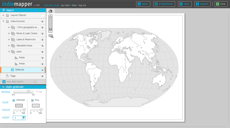
Indiemapper is in part a reaction to the frustration, confusion, and difficulty we (as cartography students, teachers, and practitioners) have encountered in using GIS for thematic mapping. Our most important principle, which I hope is visible in the image above, is simple clarity—being easy to learn, easy to understand, and easy to use. Ben Sheesley and Mark Harrower have worked tirelessly to design an interface that fits that bill. Notice that the whole thing consists of only a half dozen or so components, the most complicated of which is the layers panel on the left side (which is a real feat of Flex/AS3 wizardry by Zach, I must add), and even that can be mastered with minimal effort.
GEOGRAPHIC DATA
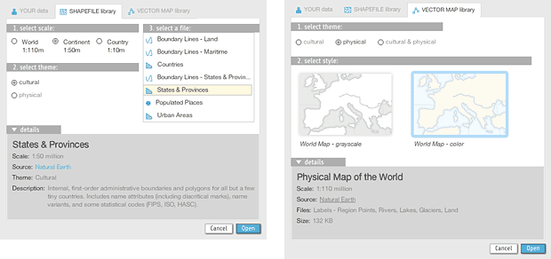
We expect that most people want to map their own data, which can be uploaded from shapefiles, KML, and GPX files. To help you get started or to augment your own data, indiemapper is also stocked with reference data from Natural Earth vector and some pre-styled world reference base maps designed by Ben in indiemapper itself.
MAP PROJECTIONS
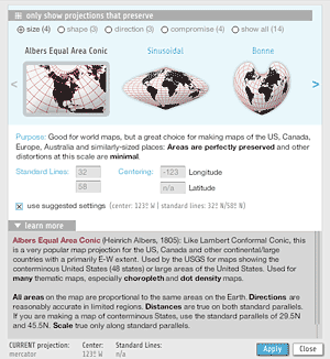
Map projections. Such pain they have caused me. But that’s a tale for another day. We ended up with fourteen projections that are a good selection of map projections suitable for most purposes. You have control over centering and standard parallels, and importantly the options are presented along with guidance and detailed information on what geometric properties each projection preserves and for what purposes the projection is appropriate.
MAP TYPES
Indiemapper has twelve basic types of thematic and reference map types, with more to come in the future. Here’s a quick rundown.
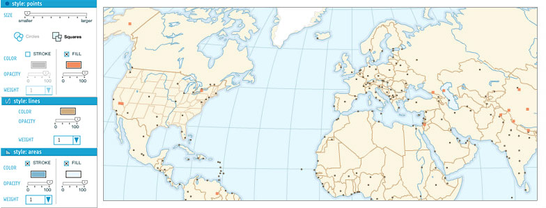
Reference points, lines, and areas. Any data source can have one or more layers depicting the base geography, and these can be combined to make some pretty nice reference maps, as you can see above in one of Ben’s base maps.
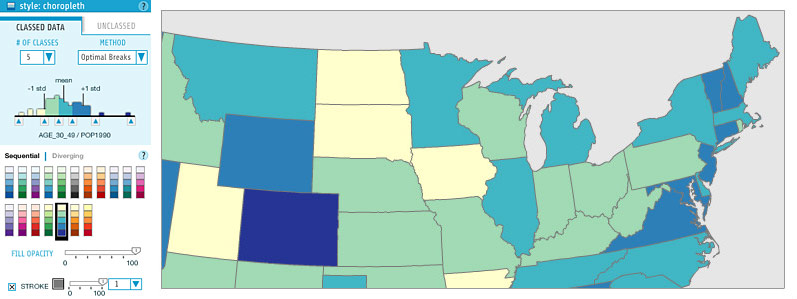
Choropleth. The bread and butter of thematic cartography. Indiemapper provides the excellent ColorBrewer color schemes and equal interval, quantile, and optimal breaks classification presets (or unclassed maps!).
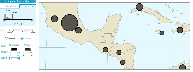
Proportional symbols. These can be created for point features or on area feature centroids. They can either be unclassed (i.e. truly proportional), or classed, a.k.a. “range-graded” or “graduated.” Proportional symbol maps can get messy, but don’t worry, you can move the symbols around on the map so they don’t overlap.
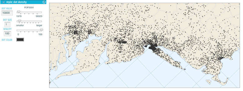
Dot density. Our dot density maps simply place dots at random within polygons. Be careful with dot density maps—they’re not effective with all arrangements of enumeration units, and remember to always use an equal-area map projection!
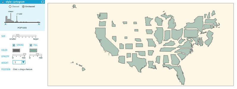
Cartogram. Here we get into pretty interesting territory. Zach built in his code for non-contiguous cartograms, and I’m not aware of any similarly easy implementation of cartograms in mapping software. Contiguous cartograms are a challenge we may take on some day, but you can make some pretty sweet (and easier to read, I’d say) maps with non-contiguous cartograms. As with proportional symbols, you can move the cartogram polygons around, and usually you’ll want to do so. Zach has gone experimental and allowed for classed cartograms here, too.
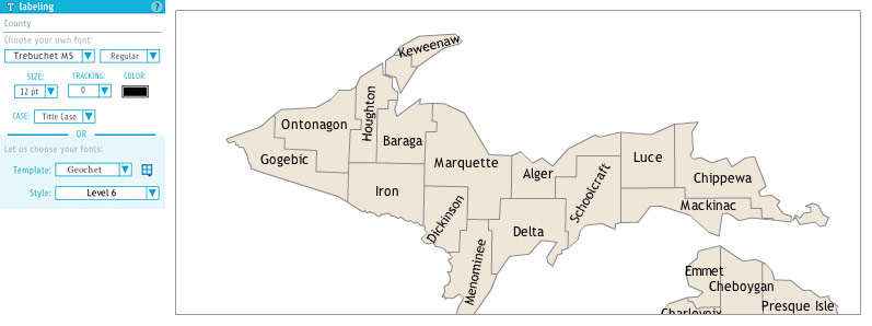
Map labels. Any cartographer will agree that labeling is a huge part of the work that goes into a map and that automated label placement is a beast that has only recently been tamed. Indiemapper gets you started with basic labeling using any attribute you choose, and then allows you to move and rotate labels as desired. You have access to all the fonts installed on your computer, as well as a selection of embedded free fonts. Ben, whose PhD is practically in map typography, has made some templates based on his TypeBrewer work, making it easy to select effective and harmonious styles.
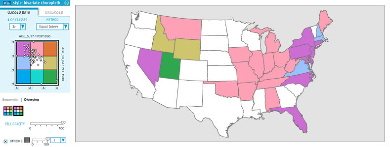
Bivariate choropleth. This is kind of a big deal. As far as I know, indiemapper makes creating bivariate choropleth way easier than ever before. It offers several sequential and diverging color schemes, automatic or manual (or no) classification, and a scatterplot to view the relationship between attributes.
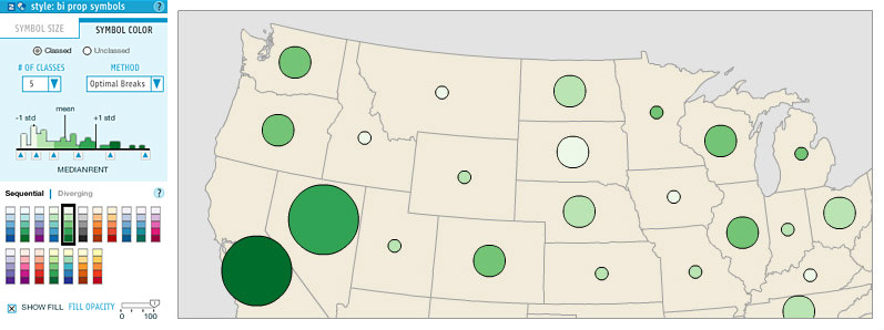
Bivariate proportional symbols. Thanks to the flexible architecture that Zach programmed, it is very easy for us to combine symbology types, so a bivariate proportional symbol map is as simple as combining a proportional symbols with a choropleth-like color scheme. Note that the styling panel essentially places the two individual style panels into two tabs.
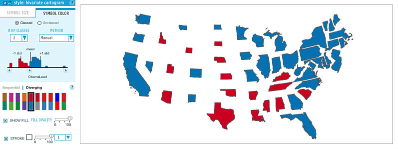
Bivariate cartograms. Again, we just combine two existing symbologies. These colored cartograms are really the best use of cartograms, showing some attribute on a perfectly equalized base map. We’ve all seen them following elections.

Value-by-alpha. This is an Axis Maps original. It’s a bivariate technique that I kind of made up in reaction to election cartograms, that was presented in our alternative election map, and was more fully developed by Robert Roth, me, and Zach in a forthcoming paper in the Cartographic Journal. One attribute is displayed by color, and another standardizing attribute by transparency. Some day I’ll finally write a post describing our work on the value-by-alpha technique.
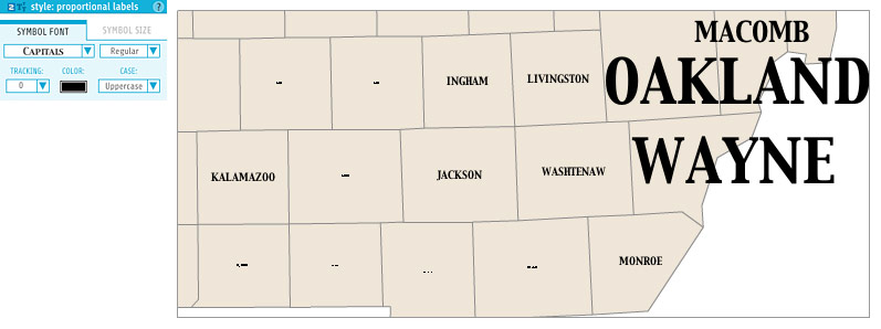
Proportional labels. You see this kind of map occasionally, where labels are scaled according to some attribute value, a bit like in a word cloud. It was easy to implement, so why not?
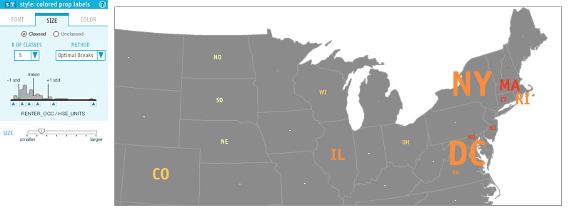
Colored proportional labels. That’s right, we have a trivariate map symbology! It says one thing, is scaled by another thing, and colored by a third.
MAP LAYOUT
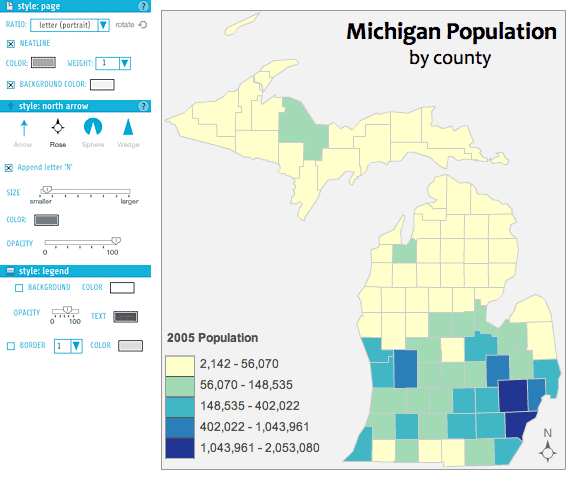
The goal of using indiemapper is to generate some sort of output image such as this Cartography 101-style map of Michigan (as vector SVG or raster JPEG and PNG), so layout controls are always available. At the center of the stage is a page that contains what will be exported in the end, and which has some style options of its own. On top of the map are several layers in a “Layout Objects” group: legends, north arrow, and annotations. Legends are generated automatically when you create a thematic layer, and they can be toggled on or off. North arrow options are, I’m sad to say, lacking dozens of garish styles. The annotation layer allows you to manually enter text for titles, labels, or what have you.
EXPERT GUIDANCE
As with the map above, there is additional information behind “learn more” buttons all over the place in indiemapper. There’s more to learn about every map type and many other features. Mark Harrower, building on his experience teaching and studying cartography as a professor at the University of Wisconsin-Madison, has written an extensive set of these “learn more” articles that teach users about cartography topics while providing guidance on best practices and how to achieve them in indiemapper. Among other things, this is one reason we think that indiemapper can be a very useful tool for students and teachers.
MAP MANAGEMENT
Save your maps online (unlimited storage), roll back to previous versions so you don’t have to worry about accidentally destroying your work, share your maps with other indiemapper users if you want to collaborate, and attach comments to map versions. Dave Heyman has built a fantastic web site and database back end to indiemapper that allows all this and so much more. It’s easy to manage all your maps from the “My Indie” page. Mark has recorded a nice video tour of all these features.
GET YOUR FACE IN THERE
Indiemapper.io. Get in there! You’ll get a 30 day free trial, and then it’s $30/month ($20 if you’re a student) with no lengthier commitments. Or you can stick to a weaker free version like a loser. You’re not a loser, are you?
Tagged axis maps, indiemapper
1 Comment